Weather Forecasting
Weather forecasting by scientists has changed over the last one hundred years. Today scientists use Doppler radar, weather satellites, and computer programs to name just a few of the instruments used to predict the weather. George Washington and Benjamin Franklin were both interested in the weather and kept weather diaries.
Benjamin Franklin
Benjamin Franklin was the first to speculate that storms moved across the United States from the west coast to the east coast. He also created and published Poor Richard's Almanac that was a guide to planting crops. Today the book is still published yearly as The Farmer's Almanac.
Weather instruments
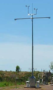
Surface meteorology stations such as the picture above record statistics every 60 seconds. The instruments record surface wind speed, wind direction, air temperature, relative humidity, barometric pressure and the rate of rain. This information is sent to national weather stations.
Forecasters of weather have been using computers to produce weather maps since the 1950s. The programs are much more sophisticated today. Information from weather satellites, weather balloons, surface instruments and radar are all fed into the computers to predict the weather.
Forecasting weather
Today forecasters will predict what the weather in the next 24 hours will be like in an area. This is called the daily forecast. Longer range forecasts predict weather for the next 7 to 10 days. These forecasts are broadcast by television news stations during the evening news. These forecasts are updated as new information comes into the newsroom.
Dangerous weather
Planes traveling through dangerous weather conditions also are given up to the minute weather information. This gives pilots time to go around large dangerous storms or not to land in areas where it would be too dangerous to make a safe landing.
More Weather Links
- Weather Forecasting Find out how meteorologists use weather instruments to predict all kinds of weather from tornadoes to blizzards.
- Polar Winds Find out about polar winds that form as frigid arctic air sinks downward and moves to lower pressures areas.
- Pacific Typhoons Pacific typhoons and Pacific hurricanes are the same storms due you know what the different is? Find out on this webpage.
- Tornado Scale Find out about the Tornado Scale and the new Enhanced Tornado Scale that measures tornadoes in the United States.
KIDS FUN SCIENCE BOOKSTORE
 |
 |
Check out Myrna Martin's award winning textbooks, e-books, videos and rock sets. The Kids Fun Science Bookstore covers a wide range of earth science topics. Click here to browse.
Sign up to our monthly newsletter and receive our FREE eBook containing 3 fun activities that don’t appear in any of our other books!
The Kids Fun Science monthly newsletter will include the following: current events, weird and fantastic facts, a question of the month, science trivia and the latest new content from our website.
We respect your privacy and you can be assured that we will never share your email address or use it for any other purpose than to send you our newsletter.


