Primary Waves
P Waves & S waves
Primary waves (p waves) are the first earthquake waves to reach reporting stations. Today, there are about 4000 reporting stations worldwide. The USGS estimates there are several million earthquakes that occur each year. Most are undetected because of their remote locations. The NEIC (Nation Earthquake Information Center) locates about 50 earthquakes each day and about 20,000 each year.
Use of seismic waves by scientists
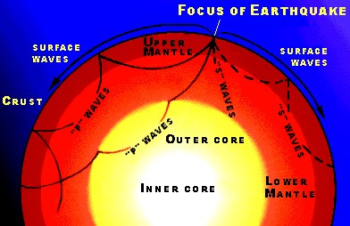
Earthquake waves are also known as seismic waves. They have been used by scientist to find the outline of tectonic plate boundaries, the boundary between the crust and mantle and the inner and outer cores of the Earth.
P waves and S waves
Large and small earthquake always produce P waves and S waves. P waves travel at different speeds depending on the density of the rocks. When the density of the rocks change at a boundary the waves speed up or slow down. They are also slightly deflected when there is a change in rock density.
P waves travel through solids, liquids and gases. The denser the rock the faster the P waves travel. P waves increase in speed when they hit the Moho boundary which separates the Earth's crust from the mantle.
2011 Japanese earthquake
During the large subduction zone earthquake off the coast of Japan on March 11, 2011 P waves traveled through the body of the Earth. They increased their speed and were slightly deflected at the Moho Boundary. They slowed down at Earth's liquid out core and again increased in speed they reached the solid inner core.
Detecting the inner core of Earth
Danish seismologist Inge Lehmann was studying earthquake waves around the world. She detected what she thought was a solid inner core using information on P waves. Dr. Lehmann published her paper in 1936. It was not until 1970 that seismographs were sensitive enough to confirm her discovery.
More Earthquakes Links
Primary Waves Find out about primary waves which are the first earthquake waves to reach reporting stations.
Mercalli Scale Find out about the Mercalli scale that measures the intensity of an earthquake rather than its magnitude.
Earthquake Zones Find out more about earthquake zones that outline tectonic plate boundaries where plates are coming together, moving apart and slipping past each other.
1960 Chile Earthquake The 1960 Chile earthquake was the largest of the 20th Century. Find out what causes this great earthquake.
Earthquake Epicenter Find out where earthquake epicenters are located and how they are determined on this webpage.
Alaska Earthquake The Great Alaskan Earthquake was the second largest earthquake of the 20th Century. Find out about the landslides and tsunamis generated during the earthquake.
Earthquake Facts Find out about the discoveries that have been made by scientists using earthquake waves including layers of the Earth and outlining tectonic plates.
Home Kids Earth Science links to all the categories on our website.
KIDS FUN SCIENCE BOOKSTORE
 |
 |
Check out Myrna Martin's award winning textbooks, e-books, videos and rock sets. The Kids Fun Science Bookstore covers a wide range of earth science topics. Click here to browse.
Sign up to our monthly newsletter and receive our FREE eBook containing 3 fun activities that don’t appear in any of our other books!
The Kids Fun Science monthly newsletter will include the following: current events, weird and fantastic facts, a question of the month, science trivia and the latest new content from our website.
We respect your privacy and you can be assured that we will never share your email address or use it for any other purpose than to send you our newsletter.


